Difference between revisions of "GilroyToCHS"
From Troop792Wiki
Jump to navigationJump to search
| (7 intermediate revisions by the same user not shown) | |||
| Line 23: | Line 23: | ||
=== route through Merced === | === route through Merced === | ||
[[File:Gilroy to CHS2.jpg]] | |||
* 1. Leave Gilroy on E 10TH ST (CA-152), go 0.1 mi | * 1. Leave Gilroy on E 10TH ST (CA-152), go 0.1 mi | ||
| Line 28: | Line 30: | ||
* 3. Turn right onto CA-152 E/Pacheco Pass Hwy. Continue to follow CA-152 E, go 64.8 mi | * 3. Turn right onto CA-152 E/Pacheco Pass Hwy. Continue to follow CA-152 E, go 64.8 mi | ||
* 4. Exit onto CA-59 N, go 15.3 mi | * 4. Exit onto CA-59 N, go 15.3 mi | ||
* 5. Turn | * 5. Turn right on W. 16th St., go 0.3 mi. | ||
* 6. Turn left on G St., go 6.6 mi. Then this becomes Snelling Rd.; go 9.4 mi. | |||
* 7. Turn right on Hwy 59, go 1.5 mi. | |||
* | * 8. Turn left onto Co Rd J59/La Grange Rd (signs for County Road J59/Don Pedro Lake). Continue to follow La Grange Rd. Go 26.1 mi | ||
* 9. Turn right onto CA-108 E/CA-120 E. Continue to follow CA-108 E. Go 36.3 mi | |||
* | * 10. The turn-out (and sign) is on the right. (This is 6.4 mi. after Long Barn.) | ||
* | |||
* | |||
* | |||
=== route through Dublin === | |||
[[Image:Gilroy to CHS3.JPG]] | |||
. | * 1. Leave Gilroy on E 10TH ST (CA-152), go 0.1 mi | ||
* 2. Merge onto US-101 N via the ramp to San Jose, go 28.5 mi | |||
* 3. Take exit 384 to merge onto I-680 N toward Sacramento, go 29.9 mi | |||
* 4. Take exit 30A to merge onto I-580 E toward Stockton, go 20.1 mi | |||
* 5. Continue straight onto I-205 E, go 14.6 mi | |||
* 6. Merge onto I-5 N, go 0.8 mi | |||
* 7. Take exit 461 to merge onto CA-120 E toward Manteca/Sonora, go 6.4 mi | |||
* 8. Keep left at the fork, follow signs for CA-99 N/Sacramento/CA-120/Sonora N and merge onto CA-120 E/CA-99 N, go 1.7 mi | |||
* 9. Take exit 242 for CA-120 E/Yosemite Ave toward Sonora, go 0.2 mi | |||
* 10. Turn right onto CA-120 E/E Yosemite Ave. Continue to follow CA-120 E, go 19.8 mi | |||
* 11. Turn left onto CA-108 E/E F St. Continue to follow CA-108 E, go 37.2 mi | |||
* 12. Turn right onto Peaceful Oak Rd, go 0.2 mi | |||
* 13. Take the 1st left onto CA-108 E/Sonora Pass Hwy, go 14.0 mi | |||
* 14. Arrive at Long Barn. Continue on Hwy. 108 for 6.4 mi. The turn-out (and sign) is on the right. | |||
Continue to follow CA-120 E | |||
Continue to follow CA-108 E | |||
* | |||
Latest revision as of 09:11, 26 July 2016
Directions from Gilroy to Camp Hi-Sierra
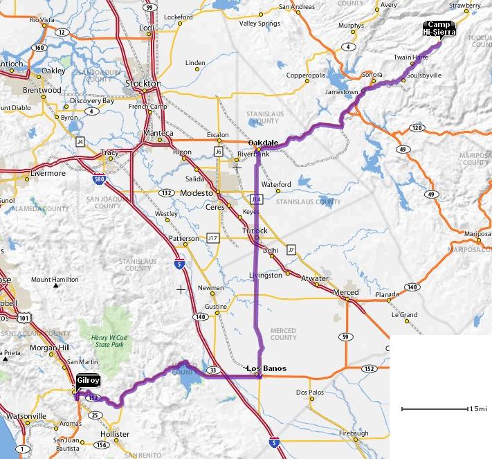
route through Turlock
- 1. Leave Gilroy on E 10TH ST (CA-152), go 0.1 mi
- 2. Continue to follow CA-152, go 2.7 mi
- 3. Bear RIGHT on PACHECO PASS HWY(CA-152), go 9.2 mi
- 4. Continue to follow CA-152, go 36.4 mi
- 5. Turn LEFT on CA-165 (Mercey Springs Rd.), go 29.6 mi
- 6. Continue on LANDER AVE(CR-J14), go 1.3 mi
- 7. Turn RIGHT on W MAIN ST in Turlock, go 0.2 mi (can also continue on Lander, becomes E. Olive Ave.)
- 8. Turn LEFT on N GOLDEN STATE BLVD(CA-99-BR), go 0.3 mi
- 9. Bear RIGHT on GEER RD (CR-J14 N), go 1.6 mi
- 10. Continue on CR-J14 (Yosemite Ave. in Oakdale and Albers Rd. before that), go 17.3 mi
- 11. Turn RIGHT on CA-108; go 51.9 mi. The jog in Sonora is at Peaceful Oak Rd.
- 12. Arrive at Long Barn. Continue on Hwy. 108 for 6.4 mi. The turn-out (and sign) is on the right.
Distance: 157 miles
Place to stop for lunch: Carl's Jr. is on the right in Oakdale.
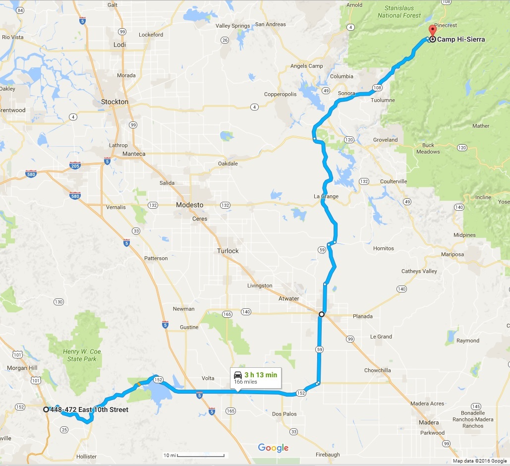
route through Merced
- 1. Leave Gilroy on E 10TH ST (CA-152), go 0.1 mi
- 2. Continue onto CA-152/Pacheco Pass Hwy, go 2.7 mi
- 3. Turn right onto CA-152 E/Pacheco Pass Hwy. Continue to follow CA-152 E, go 64.8 mi
- 4. Exit onto CA-59 N, go 15.3 mi
- 5. Turn right on W. 16th St., go 0.3 mi.
- 6. Turn left on G St., go 6.6 mi. Then this becomes Snelling Rd.; go 9.4 mi.
- 7. Turn right on Hwy 59, go 1.5 mi.
- 8. Turn left onto Co Rd J59/La Grange Rd (signs for County Road J59/Don Pedro Lake). Continue to follow La Grange Rd. Go 26.1 mi
- 9. Turn right onto CA-108 E/CA-120 E. Continue to follow CA-108 E. Go 36.3 mi
- 10. The turn-out (and sign) is on the right. (This is 6.4 mi. after Long Barn.)
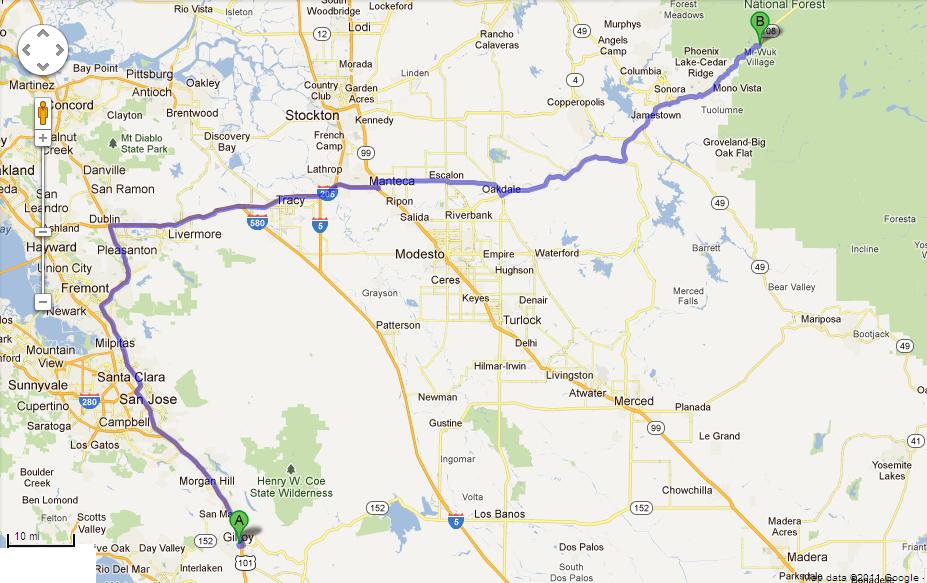
route through Dublin
- 1. Leave Gilroy on E 10TH ST (CA-152), go 0.1 mi
- 2. Merge onto US-101 N via the ramp to San Jose, go 28.5 mi
- 3. Take exit 384 to merge onto I-680 N toward Sacramento, go 29.9 mi
- 4. Take exit 30A to merge onto I-580 E toward Stockton, go 20.1 mi
- 5. Continue straight onto I-205 E, go 14.6 mi
- 6. Merge onto I-5 N, go 0.8 mi
- 7. Take exit 461 to merge onto CA-120 E toward Manteca/Sonora, go 6.4 mi
- 8. Keep left at the fork, follow signs for CA-99 N/Sacramento/CA-120/Sonora N and merge onto CA-120 E/CA-99 N, go 1.7 mi
- 9. Take exit 242 for CA-120 E/Yosemite Ave toward Sonora, go 0.2 mi
- 10. Turn right onto CA-120 E/E Yosemite Ave. Continue to follow CA-120 E, go 19.8 mi
- 11. Turn left onto CA-108 E/E F St. Continue to follow CA-108 E, go 37.2 mi
- 12. Turn right onto Peaceful Oak Rd, go 0.2 mi
- 13. Take the 1st left onto CA-108 E/Sonora Pass Hwy, go 14.0 mi
- 14. Arrive at Long Barn. Continue on Hwy. 108 for 6.4 mi. The turn-out (and sign) is on the right.


