Difference between revisions of "Scout Resources"
| Line 94: | Line 94: | ||
| [http://www.troop792.gilroyscouting.org/mb/American_Labor.pdf American Labor] | | [http://www.troop792.gilroyscouting.org/mb/American_Labor.pdf American Labor] | ||
|- | |- | ||
| http://www.troop792.gilroyscouting.org/images/5/5c/AnimalScienceMB.gif | | [[File:http://www.troop792.gilroyscouting.org/images/5/5c/AnimalScienceMB.gif]] | ||
| [http://www.troop792.gilroyscouting.org/images/4/44/Animal_Science2008.pdf Animal Science] | | [http://www.troop792.gilroyscouting.org/images/4/44/Animal_Science2008.pdf Animal Science] | ||
|- | |- | ||
Revision as of 14:54, 17 May 2012
You can find a lot of useful resources for the scouts on this page. Use these links when planning for your advancements, planning to be Master of Ceremonies (MC) for a campfire, or other things.
Advancement Requirements
First Class Requirements
Requirement 1
Demonstrate how to find directions during the day and at night without using a compass.
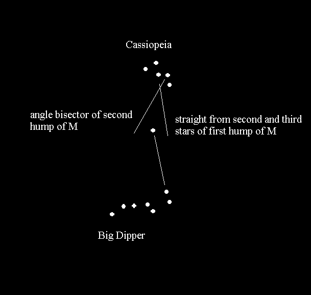
However, in the late fall and winter, the Big Dipper is below the horizon (if you are anywhere other than on a mountain top). The following picture shows how to find the North Star using Cassiopeia.

Requirement 6
- File:Broad leafs.pdf
- File:Pines firs junipers.pdf
- FirstClassR6 - Check this page to see pictures of plants you can identify.
Native plants that can be spotted at Christmas Hill Park:
- maple-leafed oak
- valley oak
- poison oak
- big-leaf maple
- coastal redwood
- coast live oak
- sycamore
- madrone
- Monterey pine
- buckeye
- wolfsfur (moss)
- sword fern
- brackenfern
- miner's lettuce
- black walnut
Campfire planning
- A wide variety of camp skits can be found here.
- Songs can be found here and here.
merit badge requirements
- Find your merit badge requirements and worksheets here.
BSA online learning center
- Adult training here.
cooking ideas
paperwork
- Forms available here.
- annual medical form
Campout Location Ideas
- Rob Hill, in the Presidio of San Francisco is closed for renovation in 2008, but might be a fun location in 2009!
Directions to Uvas Canyon Park (from Gilroy)
Starting at the intersection of First St. (Hecker Pass Hwy) and Sta. Teresa Blvd., go west on Hecker Pass for 2.8 miles. Turn right on Watsonville Road. Continue on Watsonville Rd. for 3.6 miles. Turn left on Uvas Road. Continue on Uvas Rd. for 5.9 miles. Turn left on Croy Rd. Continue on Croy Rd. for 4.4 miles, through Svedal.
<googlemap lat="37.073806" lon="-121.678391" type="map" zoom="11">
- 758BC5
37.014616, -121.573677, Gilroy, CA 37.011052, -121.617622 37.014067, -121.650581 37.027773, -121.655731 37.047779, -121.653671 37.062848, -121.667061 37.060109, -121.676674 37.071067, -121.703796 37.097976, -121.721306 37.108244, -121.732635 37.0938, -121.74448 37.085036, -121.762161 37.085173, -121.792374, Uvas County Park </googlemap>
merit-badge pamphlet details
Places to not camp (for Scouting events)
- Los Banos Creek Rsv. (4/2008)
- Edison Lake (7/2008)
Camping within 200 miles
compiled for Mene Oto Scoutmaster Breakout, Dec., 1999
- Lake Sonoma Rec. Area
- Bothe-Napa Valley State park
- Olema Ranch Campground
- Samuel P. Taylor State Park
- Point Reyes: Sky Camp Hike-In
- Point Reyes: Coast Camp Hike-In
- Point Reyes: Wildcat Camp Hike-In
- Glen Camp Hike-In
- Pantoll Campground
- China Camp State park Walk-In
- Angel Island State Park Walk-IN
- Anthony Chabot Regional Park
- Mount Diablo State Park
- Half Moon Bay State Beach
- Sunol Regional WIldreness
- Memorial County park
- Portola State Park
- Butano State Park
- Big Basin Redwoods State Park
- Caswell Memorial State Park
- Henry W. Coe State Park
- Yosemite: Bridalveil Creek
- Yosemite: Jerseydale
- Yosemite: Lower Pines
- Yosemite: Upper Pines
- Yosemite: North Pines
- Henry Cowell Redwoods State Park
- SCC Parks: Uvas Canyon County Park (Morgan Hill, CA)
- New Brighton State Beach
- Seacliff State Beach
- Manresa Beach State Park
- SCC Parks: Mt. Madonna County Park (Gilroy, CA)
- Sunset State Beach
- Fremont Peak State Park
- Ventana Campgrounds
- Pfeiffer Big Sur State Park
- Pinnacles National Monument
first aid


