Scout Resources
You can find a lot of useful resources for the scouts on this page. Use these links when planning for your advancements, planning to be Master of Ceremonies (MC) for a campfire, or other things.
First Class Requirement 1
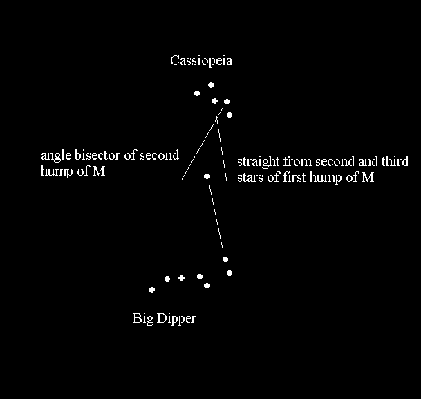
Demonstrate how to find directions during the day and at night without using a compass.
However, in the late fall and winter, the Big Dipper is below the horizon (if you are anywhere other than on a mountain top). The following picture shows how to find the North Star using Cassiopeia.
Campfire planning
- A wide variety of camp skits can be found here.
- Songs can be found here and here.
Advancement
- Find your merit badge requirements and worksheets here.
BSA online learning center
- Adult training here.
paperwork
- Forms available here.
- File:Medical Class 1 and 2.pdf
- File:Medical Class 3.pdf
Directions to Uvas Canyon Park (from Gilroy)
Starting at the intersection of First St. (Hecker Pass Hwy) and Sta. Teresa Blvd., go west on Hecker Pass for 2.8 miles. Turn right on Watsonville Road. Continue on Watsonville Rd. for 3.6 miles. Turn left on Uvas Road. Continue on Uvas Rd. for 5.9 miles. Turn left on Croy Rd. Continue on Croy Rd. for 4.4 miles, through Svedal.
<googlemap lat="37.073806" lon="-121.678391" type="map" zoom="11">
- 758BC5
37.014616, -121.573677, Gilroy, CA 37.011052, -121.617622 37.014067, -121.650581 37.027773, -121.655731 37.047779, -121.653671 37.062848, -121.667061 37.060109, -121.676674 37.071067, -121.703796 37.097976, -121.721306 37.108244, -121.732635 37.0938, -121.74448 37.085036, -121.762161 37.085173, -121.792374, Uvas County Park </googlemap>
